
Description
This one week South Switzerland itinerary brings you to some of the most iconic places of the Alps like Zermatt, the Matterhorn and Europe’s biggest glacier – the Aletsch Glacier. It’s topped with one day at Lago Maggiore in Italy.
You can stay at one place for the entire week and still everyday will be different and absolutely stunning.
| Our One Week South Switzerland Itinerary |
|---|
| Day 1: Nendaz |
| Day 2: Zermatt |
| Day 3: Stresa (Lago Maggiore) |
| Day 4: Brig |
| Day 5: Aletsch Glacier |
| Day 6: Rhône Glacier |
| Day 7: Brig & Going back |
Gallery


Overall costs
$ 1500
Duration
7 days
Rating
Public transportation timetables
Itinerary:
Nendaz


Nendaz is a mountain village in the french speaking part of the Valais Alps with some relaxed hiking opportunities. You can combine a visit here with a wine tour at Ardon.
How to get there
By train / bus: Take a train to Sion and from there Bus 362 to Haute-Nendaz.
By car: Autoroute du Rhône to Sion and then uphill Route de Nendaz.
Our hiking route
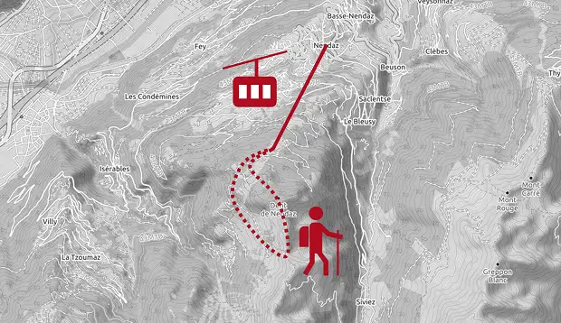
We took the cable car called Tracouet up the mountain and started a little hike from there. By taking the cable car you can skip the walk through the shady forest and just start on the sunny plateau.
Follow the direction of the cable car to Lac Noir. On the right side of the lake you will see a path leading up to the summit of Dent de Nendaz. You will reach the summit after around one hour.
Dent de Nendaz has overwhelming views down to the Rhône Valley, into the Bernese and French Alps.
After you enjoyed the view, follow the path on the summit ridge south to the next mountain called Le Basso d’Alou. Decent from here westwards the small serpentine path until you reach a broader driveway. Go right and follow the driveway back to the cable car.
Next to the driveway you will pass some of Europe’s oldest larch trees.
Nearby destinations
If you can spent some more days in the Alps I would strongly recommend to proceed to Chamonix and Mont Blanc via Col de la Forclaz. It’s a nice scenic route and Chamonix is beside Zermatt one of the highlights of the Alps.
Zermatt


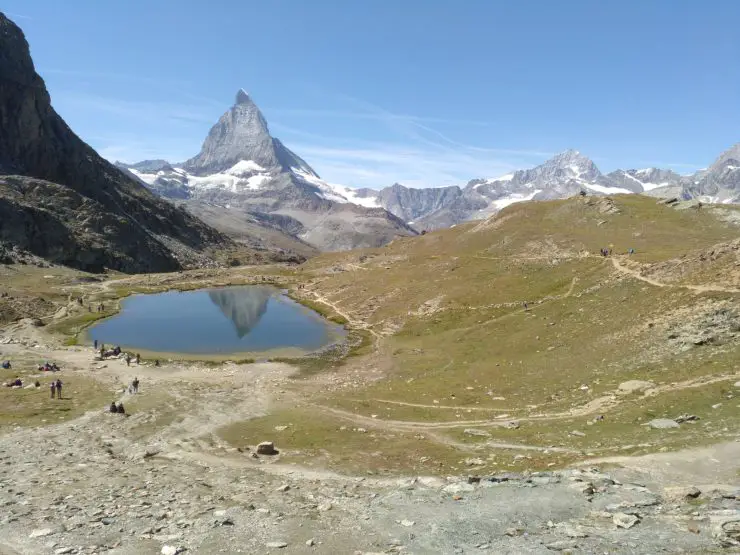
Zermatt and the nearby Matterhorn are iconic for Switzerland and one of the most visited tourist destinations in the country. There are endless hiking and other outdoor activity options in the area including Europe’s highest ski slope which is also open in the summer. Most tourists will take the rack railway up to Gornergrat at 3135 meters above sea level where you have incredible views over the Monte Rosa mountains and the Matterhorn.
How to get there
By train: There are direct train connections from Brig to Zermatt which takes around 1.5 hours. The railway line is also part of the famous Glacier Express which runs between St. Moritz and Zermatt.
For a detailed guide on what to do around St. Moritz check out our One Week Engadine Itinerary.
By car: Zermatt is a car free village so people have to park their cars at Randa and proceed from here by train to Zermatt. You will find lots of car parks just next to Randa train station.
Things to do
Gornergrat: From Zermatt train station follow the signs to Gornergratbahn which is just a few meters away. Make sure to be there early to avoid the long lines at the ticket counter. The train will then bring you up to Gornergrat where you can either stay or start a hike. Most people will stay around the summit station so once you walk away a bit you will find yourself in a peaceful alpine landscape.
Our hiking route
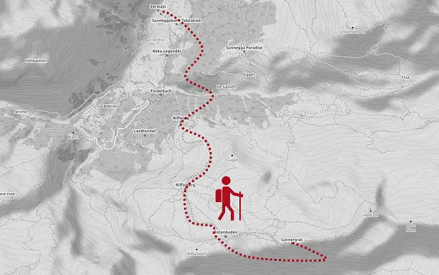
We first descended to the south towards Gorner Glacier from where you have beautiful views to Dufourspitze and Monte Rosa Hut. We then followed the path westwards until we reached Lake Riffel which has the famous panorama of the Matterhorn.
From there we walked to Riffelalm, through a light forest to Sunnegga and finally back down to Zermatt. The tour will take a whole day but you can skip the part to Sunnegga and go directly down to Zermatt which saves you easily around 2 hours.
Stresa (Lago Maggiore)
")
")
")
Stresa is a small town in Italy south of the Valais Alps on the shore of Lago Maggiore. This can be your joker on a rainy day since it has an almost mediterranean climate.
Stresa has a nice promenade with lots of restaurants and a small harbor with ferry connections and tourist boat trips. There is no better way to squeeze in a day with Pizza, Cappuccino, beach time and palm trees while being in the middle of the Alps.
How to get there
By train: The EC trains from Brig to Milano Central stops in Stresa after 55 minutes and is the fastest connection to Lago Maggiore. There are also cheaper connections via Domodossola but they take around 2.5 hours which is not the best option for a day trip.
By car: From Brig follow highway number 9 towards Simplon Pass where you cross the border to Italy. From here take the route via Domodossola to Stresa. By car you will be there in around 1.5 hours.
Things to do
Monte Mottarone: The mountain offers one of the best views over great parts of Lago Maggiore and the Valais Alps on this side of the lake. There is a cable car running up the mountain but it is almost one hour by foot from the train station and parts of the road there have no sidewalk. A taxi would therefore be a good option to get there.
We walked down from the top to Stresa. At the beginning it’s just one path leading down until you reach a little cafe after 1.5 hours. From there just follow the signs back to Stresa.
Isola dei Pescatori: The small island is one of the three Borromean Islands and easily accessible by boat in 10 minutes from Stresa. It’s almost completely covered by a small village with old houses and lots of restaurants. We had an afternoon snack there and just sat by the water for a while with an ice cream to enjoy the great views over the lake and the Alps.
Brig


You can stay around Brig for the entire week and drive to the different spots each day. All places mentioned here are also well-connected by the Swiss high quality public transportation.
Brig has a beautiful old town and is also a good place for traditional dishes like Raclette.
Zeneggen hiking trail
Just a few minutes from Brig is the beautiful small village of Zeneggen with its traditional houses. It’s a 20 minute drive by car or bus from Brig.
We made a smaller 3 hours hiking tour around the village with nice views towards Vispertimen on the other side of the valley which is Swiss highest vineyard.
You can find a german description of the tour (number 5) as well as a kmz-file on the official website of Zeneggen.
Aletsch Glacier


Aletsch Glacier is the largest glacier of the Alps with around 23km length and up to 1000m thickness. Four smaller glaciers combine to a massive ice field which then flows down a broad valley. The upper part is best seen from Jungfraujoch which is accessible from the north. We visited the massive glacier tongue with a day hike starting at Bettmeralp.
How to get there
Take the train to Betten or park your car at Betten train station. In the same building starts the cable car up to Bettmeralp which is a car free mountain village.
Our hiking route
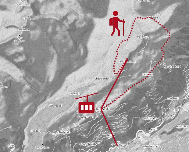
We walked east through the small village and took another cable car up to Bettmerhorn. Just a few minutes away you will find a platform with views to the glacier. Follow the hiking path downhill for around 20 minutes. It will then go eastwards above the glacier on a narrow but flat path until you reach the glacier. This part takes around 2 hours. Once you touched the ice head south to Lake Vordersee where you can take a small tunnel as a short cut back to Bettmeralp.
Rhône Glacier


The Rhone Glacier is the source of the identically named river which flows through the Provence into the Mediterranean Sea.
The glacier marks the end of the Valais Valley.
You have to pay a little fee to get access to the vista points with the best views to the ice. There is also a small tunnel leading into the blue ice which is also included in the fee.
You can start some proper day hikes from the glacier and visit the tunnel and vista points after your hiking tour.
How to get there
By car: There are free parking lots opposite to the famous Hotel Belvédère. The Furka Pass road connects the Valais Valley with Uri at around 2.400m above sea level and is passable throughout the year with vehicles up to 2,55m width.
By bus / train: There is also a bus station directly at the parking lot which is in operation from the end of June until the end of September. The bus starts in the valley at Oberwald from where you can connect to the Valais train network.
Our hiking route
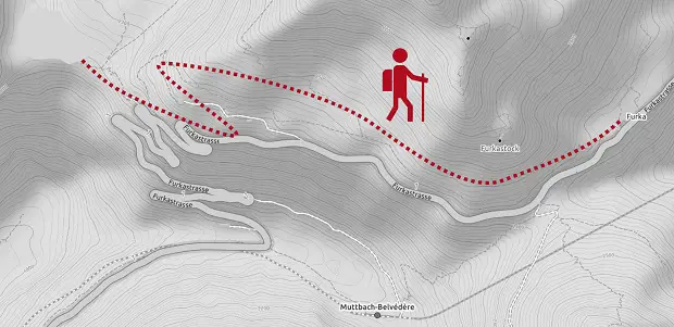
The hike takes around 2.5 hours and leads you from the glacier to the Furkapass and back. Follow the street uphill for 900m until you see a sign on the left side with the trail towards Furkapass. From there you just have to follow the small path until you reach the pass. We took the same route back to the glacier where we paid the entrance fee of 9 CHF to get to the vista points and into the ice tunnel.
Alternative route at Grimselpass
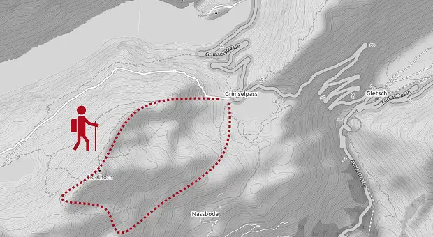
Another option with great views over the Central Alps is the route from Grindelpass up to Sidelhorn. The hike takes around 3.5 hours and starts at the parking lot of Grimselpass. You reach the pass with your own car or by bus from the train station in Oberwald.
Grimselpass is not far away from the Rhône Glacier on the continental divide which separates the river systems of the North Sea and the Mediterranean Sea.
Wow, lovely site. Thnx …