
Description
The Vinschgau Valley (Val Venosta in Italian) is a wide valley in the Italian Alps surrounded by high mountains on all sides which shelters it from humid air. This results in a sunny and dry climate all year round and makes it the perfect destination for any outdoor activity. From cycling to hiking, skiing and superb dining, the valley has plenty of everything packed into one place.
We visited the area after spending one week in the neighboring Engadine region of Switzerland.
| Our One Week Vinschgau Itinerary |
|---|
| Day 1: Reschensee (Lago di Rèsia) |
| Day 2: Prad (Prato) |
| Day 3: Sulden (Solda) |
| Day 4: Tschars (Ciardes) |
| Day 5: Stilfs (Stelvio) |
| Day 6: Schluderns (Sluderno) |
| Day 7: Meran (Merano) |
Gallery


Overall costs
$ 1200
Duration
7 days
Rating
Itinerary:
Reschensee (Lago di Rèsia)


Lake Reschen is an artificial lake in the northwestern part of the Vinschgau Valley close to the Austrian border. A village was flooded for its creation in 1950 with the old bell tower of an 14th century church left over as a landmark. The view of the bell tower is nowadays the main attraction of the lake.
You have impressive views to the snow-capped Ortler mountains from the lake and its shores.
How to get there
By car: From Nauders in Austria in around 10 minutes over the border to Italy and from Mals in the valley around 20 minutes uphill road SS40.
By bus: Bus line 273 from Mals takes 25 minutes to Graun which is the biggest village on the lake.
Things to do
Kite surfing: The lake has some strong winds and is a good place for any wind dependent water activities. A kite surf school is located outside of Grau.
Boat trip: A 45 minutes boat trip costs € 10. Tickets can be bought on board; the boat starts in Graun several times a day depending on the season. The Homepage is only available in German and Italian.
Walking: A panoramic walkway surrounds the lake and can be easily done in 3.5 to 4 hours. It’s almost flat and most parts are paved.
Prad (Prato)


The charming little village of Prad is located in the east of the Vinschgau Valley close to the Stelvio Pass Road and the Ortler Mountains. It’s the perfect place to stay if you want to explore the lower parts of the sunny Vinschgau Valley and the high mountains.
The village itself has a good number of restaurants, three supermarkets and a weekly farmers market. We stayed there for the entire week.
How to get there
By car: From Austria over Reschen Pass on SS40 and from Switzerland through Val Müstair in the Engadine region on SS41.
By train: Prad has a train station a bit off the village center with a stop of the Vinschgau train line.
By bus: From Switzerland via Post Auto to Mals and from there by bus to Prad.
Get around
Prad is a small village with everything reachable in a few minutes by foot. A car is the best option to get to the many hiking routes and a bicycle if you stay in the lower parts of the valley.
Things to do
Farmers Market: Every Tuesday from 7.30 am to 1 pm at the main square next to Mpreis supermarket. You will find local cheese, bacon and seasonal vegetables.
Rio Solda: Once the Sulden River has passed through Prad it runs through a wide floodplain before it flows into the Adige River. The floodplain itself is not accessible but there is a big recreation area on the eastern side with views to the surrounding mountains and the river banks. Part of the area is a fishpond with restaurant where you can have coffee, lunch or just buy an ice cream.
Frauwaal: A hiking path on an old water channel. You can walk as far as Glurns (medieval town) and return back by bus.
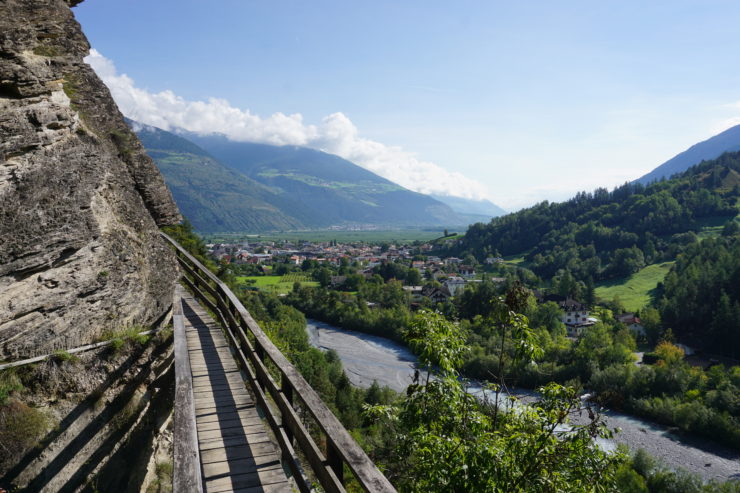
Sulden (Solda)


Sulden is a village at the foot of the Ortler mountains which are the second highest mountains of the Easter Alps after the Bernina Range. The village is located at an elevation of 1906 m (6253 ft.) and is well-known for its hiking and skiing opportunities. There are several cable cars to different summits all around the village as well as a large number of mountain huts.
How to get there
By car: From Prad via SS38 to Gomagoi and from there on SS622 to Sulden. Driving time is around 30 minutes.
By bus: Line 271 from Prad via Stilfs to Sulden takes 53 minutes.
Get around
Sulden spreads over the whole valley bottom with a few houses here and there and some pastures in between. In most cases it is possible to walk but it might also make sense to take the bus if possible.
Things to do
Düsseldorfer Hütte (Rifugio Serristori): This mountain hut has a restaurant and a sundeck with some of the best views of the snow-capped Ortler mountains. You can either walk up the whole way from the valley or take the cable car (Kanzel Lift) half way up. Walking time is around 3-4 hours. Get GPS track here.
Schaubachhütte: An easy way to get really close to the icy mountains is by cable car (Funivie di Solda) up to the mountain hut Schaubachhütte. From here you can walk in slow pace downhill back to Sulden in around 3.5 hours.
Messner Mountain Museum: The famous mountaineer operates a museum in the valley with an exhibition of ice and the Ortler. Part of the complex is a restaurant serving local and Nepalese cuisine. A yak herd can be seen next to the restaurant.
Tschars (Ciardes)


Tschars is a small village in the middle of the giant apple fields. The south faced hills behind Tschars have the valley characteristic steppes vegetation which is pervaded by old irrigation channels used for the valleys agricultural use. These channels mostly have a small footpath for maintenance purposes alongside and due to the water, there are often shady trees which results in great hiking trails.
How to get there
By car: From anywhere in the valley on the main road SS38. Free parking is available at the train station and the intersection of Via Principale and Via Rasl.
By train: Vinschgau railway has a stop in Tschars close to the Adige River. The village center is reached after a 10-minute uphill walk.
Get around
Tschars is small village and is best explored by foot.
Things to do
Hike to Juval Castle: Beautiful hiking trail along the irrigation channels to Juval Castle which is the summer residence of the famous mountaineer Reinhold Messner. The trail can be in excessive heat during the summer so bring enough water and some snacks. Walking time around 4 hours.
Castelbello: The neighboring village of Castelbello has a beautiful castle which can be reached on a moderate hiking trail in one hour.
Schnalstal (Val Senales): Narrow side valley of the Vinschgau which leads into the high Ötztal Alps. There’s a beautiful water reservoir at the end of the valley and the famous mummy “Ötzi” was found at the nearby glacier in 1991.
Stilfs (Stelvio)


The pass road Stilfser Joch (Passo dello Stelvio) is by far more popular than the small village who lend its name to this famous mountain pass. While the village itself is not the biggest attraction, there are some really nice hiking trails just outside Stilfs.
How to get there
By car: From Prad in around 15 minutes via national road SS38.
By bus: Bus line 271 from Prad to Stilfs in 17 minutes.
Get around
While you can start some activities in the village center, you’re better off with a car to reach the various places. It’s a mountainous area where you can easily add some extra hours of walking time for small distances.
Things to do
Hiking: A moderate 5-hour walking tour starts at Stilfs game reserve which has free parking. You will pass three mountain pastures which serve food and drinks in the summer.
Stilfser Joch: Being one of the most popular mountain passes of the Alps it is actually a quite narrow road with lots of traffic especially on sunny summer days. A motorbike is the best way to get around the many cyclists and cars.
Schluderns (Sluderno)


Charming little village with great mountain views at the entrance of the small Val di Mazia (Matsch Valley). The water of the valley’s creek is used in several irrigation channels and a hike along them is one of the best things to do in Schluderns.
Above the village is a well-preserved castle (Churburg) from the 12th century.
How to get there
By car: Located on the main road through the valley SS38. Free parking is available at the train station.
By train: Schluderns has a train station which is served by the Vinschgau railway line.
Get around
Streets are narrow and toward Churburg you will find many stairs so it’s easiest to go around by foot.
Things to do
Waalweg: Moderate hiking trail along the irrigation channels of Val di Mazia. It starts with a steep ascent to the first water channel from where you make your way on a flat trail to a small bridge. From here you walk back on the other side of the valley on another irrigation channel. Beautiful views especially on the second part of the trail.
Churburg: The castle is passed on the above-mentioned hiking trail but it is also possible to participate in a guided tour. An appointment is required via phone, see details on their homepage – German and Italian only.
Meran (Merano)


Meran is not a part of the Vinschgau Valley itself but is the biggest town of the area and in many ways related to the valley. The city is well-known for its mild climate and subtropical plants. Being on the foothill of the high Texel Alps it has the typical mixture of South Tyrol with Mediterranean influences in the valleys and the harsh alpine climate on its mountains.
How to get there
By car: 30 minutes from Bolzano via SS38, 2 hours from Verona via A22 and also 2 hours from Innsbruck in Austria via Brenner Pass.
By train: Long distance trains from Austria and Italy to Bolzano and from there with the regional train to Meran.
By plane: Closest airport is located in Bolzano but tickets often tend to be expensive. Cheaper flights but longer travel times can be taken to Verona or Innsbruck.
Get around
Meran is small city so it’s even possible to get around the suburbs by foot. For longer distances you can either use the busses, Vinschgau train line or the cable car up to the mountains.
Things to do
Texel Alps: Being part of the high Central Alps there are great hiking opportunities above the city. The cable-cars valley station is located in Parcheggio, 15 minutes away by car or 40 minutes with bus line 213. A famous multi day trek called “Meraner Höhenweg” goes around the mountains.
Meran 2000: The cities closest ski resort and summer hiking area offers great panoramic views to the Dolomites.
Gardens of Trauttmansdorff Castle: Nice park with subtropical plants, sculptures and a castle.
The very south: The valley in which Meran is located in opens up to the south allowing the warm air from Northern Italy to flow into the area. Due to the mild weather, grapes are cultivated in the valley. A beautiful area with the warmest lake of the Alps and stunning vistas can be seen around Kaltern. For a detailed itinerary check out this guide about Kaltern, Lake Garda and the Dolomites.