
Description
Itinerary of one week in the winter on the Canary Island of Gran Canaria. We had a mixture of hiking, surfing and relaxing on the beach. The easiest way to get around is a rental car and luckily they are very cheap on the island. We booked a place in the south for the entire week close to Maspalomas.
You can easily combine this itinerary with an extension to one of the other Canary Islands like Lanzarote or Tenerife.
| Our One Week Gran Canaria Itinerary |
|---|
| Day 1: Arrival & Beach Time |
| Day 2: Maspalomas Dunes & Puerto de Mogán |
| Day 3: Valle de Agaete |
| Day 4 & 5: Hiking in the center |
| Day 6: Las Palmas |
| Day 7: Departure |
Gallery


Overall costs
$ 800
Duration
7 days
Rating
General information
You should get a rental car for your entire stay since public transportation won’t get you to all places mentioned here. Rental cars are cheap and in great condition throughout all Canary Islands. If you plan to visit more than one island consider renting a separate car on each island. Taking a car on a ferry is expensive and many rental companies don’t allow it anyway.
Itinerary:
Maspalomas Dunes


The dunes of Maspalomas form the southern tip of the island and are a protected area. Despite its yellow color the sand doesn’t origin from the Sahara Desert but instead consists of sand of a former marine shelf. You can access the dunes on marked paths with constant views to the mountains of the inner island. The shore of the protected area is one big sandy beach and of course it’s the most popular one on the island.
How to get there
By car: There is a big parking lot just next to the dunes at Calle las Dunas in Playa del Inglés.
Things to do
You can walk through the dunes, enjoy one of the many bars at Playa del Inglés, rent some water sport equipment like stand-up paddling boards or just go for a swim in the ocean. We would recommend to first take a walk through the dunes and then make your way back along the beach with several stops to jump into the water.
Our hiking route
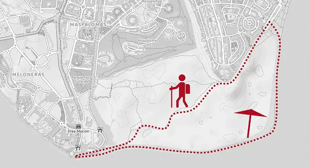
Follow the parking lot at Calle las Dunas to the end and you will see some steps leading into the sand. This is the start of a trail that leads you in several variants through the dunes to a small lagoon called La Charca de Maspalomas. It doesn’t matter which path you follow, they will all lead you to the same spot. Once you reached the lagoon you can take a look at the lighthouse and then start your walk back along the beach. There are a few kiosks for drinks at the beach but you should make sure to have enough water and sun protection since there is no shadow on the entire route.
Puerto de Mogán


Puerto de Mogán is a small harbor village and famous for its colorful houses. The village was built in the 80s next to an older village in a consistent traditional style.
How to get there
From the south follow highway GC-1 westwards to Puerto de Mogán and then head down the hill into town. There is a parking lot on the harbor wall which has the best chances of free space close to the center.
Things to do
Walk through the village and enjoy the many flowers, yachts and picturesque houses. The village is also a good place to eat and enjoy a coffee in the sun. Above the old village is a nice viewpoint called Mirador Mogan. Next to the harbor is Playa Mogan which is an artificial sandy beach.
Valle de Agaete


Valle de Agaete is located in the north-west and maybe the greenest place of the island. Due to its more humid climate it is possible to grow all kinds of tropical fruits in the valley.
How to get there
From the south follow highway GC-1 towards Las Palmas de Gran Canaria and from there follow GC-2 until you get to Agaete. On the first roundabout take GC-231 into the valley.
Things to do
Coffee Tours: We visited a farm (Bodega Finca La Laja) where they plant any kind of tropical plants such as mangos and coffee. We made a little tour to the coffee plants, saw the roasting and tried some of their coffee. There are several other similar farms in the valley, we just had a nice experience with them.
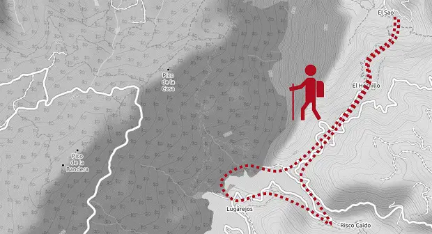
Hiking: At the end of the valley in El Sao starts a nice hiking trail up to El Hornillo and around the water reservoir Presa de los Pérez. You can park your car in El Sao and the tour takes around 4 hours walking time.
Scenery: On the way back to the south, we drove GC-200 which leads you along the entire steep west coast of the island. There are several viewpoints to take a break and nice views to the neighboring island of Tenerife with Spain’s highest Mountain Teide. It is a windy road but I highly recommend driving it once during your stay in Gran Canaria. Best time would be early morning or in the afternoon.
Hiking in the center


Gran Canaria is well-known for its many hiking trails and the winter months are the perfect time for them. Most routes can be found in the mountainous center.
Roque Nublo
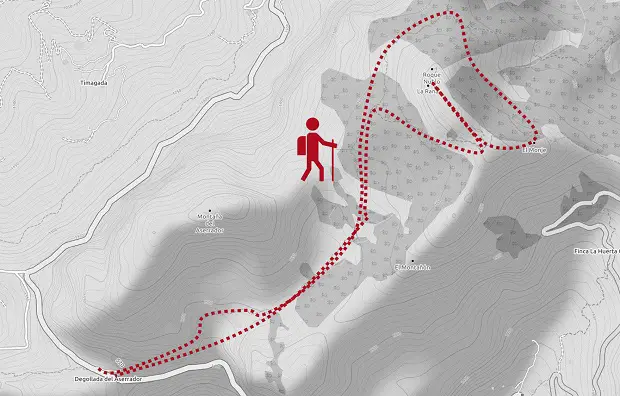
Gran Canarias landmark is a rock in the middle of the island called Roque Nublo. It is surrounded by pine forest and there are many hiking trails to get there. We choose a less crowded trail that starts at the mountain pass Hoya de la Vieja on GC-60. There is a small parking lot on the side of the road opposite to a concrete water reservoir. The trail starts next to the reservoir and leads you up towards Roque Nublo. We first walked around the rock like mentioned in the GPS route and then up to have closer look. Walking time is around 3 hours.
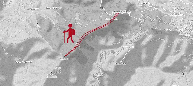
Altavista
This route leads you to one of the few real summits on the island through pine forest and great views over the inland mountains on one side and the ocean on the other side. The tour starts at Mirador del Sargento where you must park your car on the side of the road. You will notice a hiking trail uphill and a sign leads you the way to Altavista. It starts easy through the forests and gets a bit steep at the end. We met just a few people on the trek but it was the one we liked the most during our stay. Walking time is around 4 hours.
Santa Lucia de Tirajana
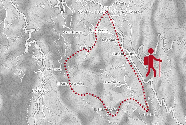
This varied trek leads you through dry fields, to a historical cave, an artificial lake and small villages. The tour starts at the church of Santa Lucia de Tirajana where you find a small parking lot free of charge. Once you’ve left the village you walk on a small path through dry bushland and corn fields. Soon you will reach the caves of Fortaleza de Ansit which served the indigenous of the Canary Islands as homes and cemetery. You then walk down to the water reservoir, cross the dam and continue the way back to Lanta Lucia on the other side of the canyon. Walking time is around 5 hours on easy paths.
Las Palmas


Las Palmas is the capital and largest city of Gran Canaria. It has a lot of history, beaches, a university and a proper nightlife.
How to get there
Follow highway GC-1 from the south or GC-2 from the north. There are also several bus lines from every part of the island going to Las Palmas.
Things to do
Old town: The old historic quarter is located around Catedral de Santa Ana. You can go up on the roof for views into the backyards of the complex and around the nearby area. Just next to the cathedral you’ll find Casa de Colon Museum which served the governor of the island as a resident and it is said that Christopher Columbus spent some time there before he set off to his expeditions.
Good quarters to go out are Triana and Vegueta.
Surfing: Playa de Las Canteras is the symbol of the city and very popular by its inhabitants. There are several surf schools offering boards and lessons on the walkway.